| Location |
| City: | | Saranac Lake, New York, United States |
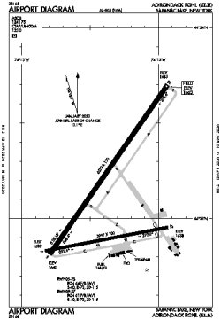
| Name: | Adirondack Regional |
| ICAO / IATA: | KSLK / SLK |
| FAA: | SLK |
Details |
| Type: | Airport (Part 139 Class IV) |
| Use: | Public/Civil |
| Latitude: | 44°23'07"N (44.385308) |
| Longitude: | 74°12'22"W (-74.206180) |
| Datum: | WGS 1984 |
| Elevation: | 1662 ft (507 m) |
| Runways: | 2 |
| Longest: | 6573 × 150 ft (2003 × 45.5 m) |
Time |
| Timezone: | UTC+29:08 (DST+32:08) |
| Local Time: | |
Weather |
| METAR: | KSLK | 041402Z AUTO 26004KT 1 1/2SM BR OVC004 04/04 A2994 RMK AO2 RAE1356 P0000 T00390039
|
| TAF: | KSLK | 041125Z 0412/0512 23010G19KT 2SM -SHRA BR OVC004
FM042200 19006KT P6SM BKN020
FM050300 19009G17KT P6SM VCSH BKN060 WS020/22040KT
FM050500 20012G22KT 4SM -RA BR OVC035 WS020/21045KT
FM050900 22015G27KT 4SM -RA BR OVC007
|
Related Locations |
| Nearby: | |
| Farthest: | YAUG: 11579 mi / 18635 km
Augusta [Augusta Airport], WA, AU |
Find: |
|
Other Information |
Maps:
|
Links:
|
Sources:
|
|