| Location |
| City: | | Santa Monica, California, United States |
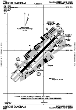
| Name: | Santa Monica Municipal Airport |
| ICAO / IATA: | KSMO / SMO |
| FAA: | SMO |
Details |
| Type: | Airport (Airfield) |
| Use: | Public/Civil |
| Latitude: | 34°00'57"N (34.015822) |
| Longitude: | 118°27'05"W (-118.451305) |
| Datum: | WGS 1984 |
| Elevation: | 169 ft (52 m) |
| Runways: | 1 |
| Longest: | 3500 × 150 ft (1067 × 45.5 m) |
Time |
| Timezone: | UTC+26:08 (DST+29:08) |
| Local Time: | |
Weather |
| METAR: | KSMO | 041351Z AUTO 21006KT 10SM FEW019 SCT044 14/10 A2982 RMK AO2 SLP097 T01440100
|
| TAF: | KSMO | 041146Z 0412/0512 12005KT 6SM -SHRA SCT015 OVC030
FM041500 16010KT 6SM -SHRA SCT015 OVC035
FM041900 17012KT 4SM RA BR OVC015
FM042200 23015G23KT 5SM -RA BR SCT015 OVC025
FM050300 25012KT P6SM -SHRA BKN025 OVC040
FM050700 26008KT P6SM -SHRA SCT025 OVC040
|
Related Locations |
| Nearby: | |
| Farthest: | ZSE: 11482 mi / 18478 km
St-Pierre (St-Pierre de la Réunion) [Pierrefonds], RE |
Find: |
|
Other Information |
Maps:
|
Links:
|
Sources:
|
|