| Location |
| City: | | Springfield, Illinois, United States |
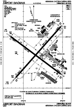
| Name: | Abraham Lincoln Capital Airport |
| ICAO / IATA: | KSPI / SPI |
| FAA: | SPI |
Details |
| Type: | Airport (Part 139 Class I) |
| Use: | Public/Civil |
| Latitude: | 39°50'41"N (39.844614) |
| Longitude: | 89°40'39"W (-89.677546) |
| Datum: | WGS 1984 |
| Elevation: | 597 ft (182 m) |
| Runways: | 2 |
| Longest: | 8001 × 150 ft (2439 × 45.5 m) |
Time |
| Timezone: | UTC+28:08 (DST+31:08) |
| Local Time: | |
Weather |
| METAR: | KSPI | 041352Z 18017KT 9SM FEW050 OVC070 11/10 A2971 RMK AO2 SLP063 T01060100 $
|
| TAF: | KSPI | 041348Z 0414/0512 18015G22KT P6SM VCSH SCT015 OVC060 WS015/21045KT TEMPO 0414/0416 5SM -SHRA BR BKN015 OVC035
FM041600 18012G20KT P6SM VCSH OVC015
FM041800 21012KT P6SM VCSH OVC013
FM042000 31013KT P6SM OVC010
FM050100 32011KT P6SM SCT015
|
Related Locations |
| Nearby: | |
| Farthest: | YAUG: 11023 mi / 17741 km
Augusta [Augusta Airport], WA, AU |
Find: |
|
Other Information |
Maps:
|
Delays:
|
Links:
|
Sources:
|
|