| Location |
| City: | | London, Essex, England, United Kingdom |
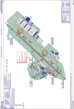
| Name: | Stansted Airport |
| ICAO / IATA: | EGSS / STN |
Details |
| Type: | Airport (Aerodrome, Airfield) |
| Use: | Public/Civil |
| Latitude: | 51°53'06"N (51.885000) |
| Longitude: | 0°14'06"E (0.235000) |
| Elevation: | 348 ft (106 m) |
| Runways: | 1 |
| Longest: | 10003 × 151 ft (3049 × 46 m) |
Time |
| Timezone: | UTC+0 (DST+3) |
| Local Time: | |
Weather |
| METAR: | EGSS | 041350Z AUTO 22010KT 2900 -RA OVC003 08/07 Q1016 REDZ
|
| TAF: | EGSS | 041103Z 0412/0518 19014KT 6000 -RA BKN006 TEMPO 0412/0413 20018G28KT 4000 RADZ BKN004 BECMG 0413/0416 29007KT 2000 BR BKN004 PROB30 0413/0418 0200 FG BKN001 BECMG 0418/0421 9999 NSW FEW004 BECMG 0421/0424 6000 PROB40 0500/0510 0200 FZFG VV/// BECMG 0510/0513 16010KT BKN007 PROB40 TEMPO 0510/0514 3000 BR BKN004
|
Related Locations |
| Nearby: | |
| Farthest: | CHT: 11852 mi / 19074 km
Waitangi [Tuuta], CIT, NZ |
Find: |
|
Other Information |
Maps:
|
Links:
|
Sources:
|
|