| Location |
| City: | | Charlotte Amalie, St. Thomas, Virgin Islands, United States |
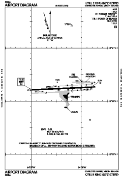
| Name: | Cyril E. King Airport |
| ICAO / IATA: | TIST / STT |
| FAA: | STT |
Details |
| Type: | Airport (Part 139 Class I) |
| Use: | Public/Civil |
| Latitude: | 18°20'14"N (18.337306) |
| Longitude: | 64°58'24"W (-64.973332) |
| Datum: | WGS 1984 |
| Elevation: | 23 ft (7 m) |
| Runways: | 1 |
| Longest: | 7000 × 150 ft (2134 × 45.5 m) |
Time |
| Timezone: | UTC+30:08 (DST+32:08) |
| Local Time: | |
Weather |
| METAR: | TIST | 041353Z 11010KT 10SM FEW030 27/20 A3003 RMK AO2 SLP170 T02670200 $
|
| TAF: | TIST | 041141Z 0412/0512 10008KT P6SM FEW025
FM041400 13012KT P6SM SCT030
FM042200 09008KT P6SM FEW025
|
Related Locations |
| Nearby: | |
| Farthest: | BWB: 12255 mi / 19722 km
Barrow Island, WA, AU |
Find: |
|
Other Information |
Maps:
|
Links:
|
Sources:
|
|