| Location |
| City: | | Hailey/Sun Valley, Idaho, United States |
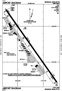
| Name: | Friedman Memorial Airport |
| ICAO / IATA: | KSUN / SUN |
| FAA: | SUN |
Details |
| Type: | Airport (Part 139 Class I) |
| Use: | Public/Civil |
| Latitude: | 43°30'14"N (43.503781) |
| Longitude: | 114°17'44"W (-114.295557) |
| Datum: | WGS 1984 |
| Elevation: | 5319 ft (1621 m) |
| Runways: | 1 |
| Longest: | 7550 × 100 ft (2301 × 30.5 m) |
Time |
| Timezone: | UTC+27:08 (DST+30:08) |
| Local Time: | |
Weather |
| METAR: | KSUN | 041347Z 20003KT 3SM -SN BKN009 OVC018 01/M02 A2947
|
| TAF: | KSUN | 041310Z 0413/0518 17009KT 6SM -SHSN BKN010 OVC020 TEMPO 0413/0415 2SM -SN BR SCT002 OVC004
FM041500 15008KT P6SM VCSH SCT025 BKN035
FM042000 19010KT 6SM -SHRASN BKN020 OVC035
FM050300 13005KT P6SM VCSH SCT025 BKN060
FM050700 14006KT 2SM -SN BR SCT006 OVC015
|
Related Locations |
| Nearby: | |
| Farthest: | FAME: 11068 mi / 17812 km
Marion Island, Prince Edward Islands, WC, ZA |
Find: |
|
Other Information |
Maps:
|
Delays:
|
Links:
|
Sources:
|
|