| Location |
| City: | | St. Louis, Missouri, United States |
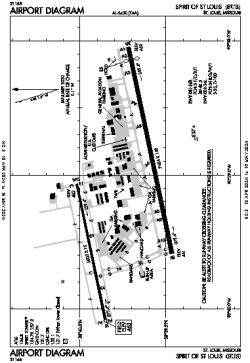
| Name: | Spirit of St. Louis Airport |
| ICAO / IATA: | KSUS / SUS |
| FAA: | SUS |
Details |
| Type: | Airport (Part 139 Class IV) |
| Use: | Public/Civil |
| Latitude: | 38°39'44"N (38.662111) |
| Longitude: | 90°39'07"W (-90.652055) |
| Datum: | WGS 1984 |
| Elevation: | 463 ft (141 m) |
| Runways: | 2 |
| Longest: | 7485 × 150 ft (2281 × 45.5 m) |
Time |
| Timezone: | UTC+28:08 (DST+31:08) |
| Local Time: | |
Weather |
| METAR: | KSUS | 041354Z 09004KT 7SM OVC028 11/09 A2974 RMK AO2 SLP069 T01060094
|
| TAF: | KSUS | 041120Z 0412/0512 15008KT P6SM SCT015 OVC020
FM041400 18008KT P6SM OVC018
FM041800 23009KT P6SM VCSH OVC014
FM042100 32012G20KT P6SM OVC008
FM042300 33012KT P6SM OVC015
FM050300 34005KT P6SM BKN015
|
Related Locations |
| Nearby: | |
| Farthest: | YAUG: 10980 mi / 17671 km
Augusta [Augusta Airport], WA, AU |
Find: |
|
Other Information |
Maps:
|
Links:
|
Sources:
|
|