| Location |
| City: | | Stavanger, Norway |
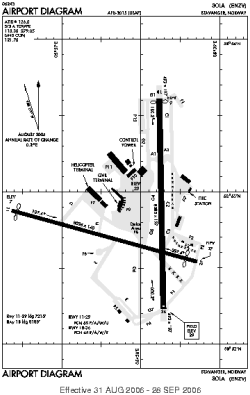
| Name: | Sola |
| ICAO / IATA: | ENZV / SVG |
Details |
| Type: | Airport (Aerodrome, Airfield) |
| Use: | Public/Civil |
| Latitude: | 58°52'36"N (58.876778) |
| Longitude: | 5°38'16"E (5.637856) |
| Datum: | WGS 1984 |
| Elevation: | 29 ft (9 m) |
| Runways: | 2 |
| Longest: | 8385 × 197 ft (2556 × 60 m) |
Time |
| Timezone: | UTC+1 (DST+4) |
| Local Time: | |
Weather |
| METAR: | ENZV | 041420Z 12010KT 9999 -RA FEW006 SCT010 BKN014 04/03 Q1002 TEMPO 4000 RADZ BR
|
| TAF: | ENZV | 041100Z 0412/0512 13012KT 9999 -RA FEW010 BKN015 TEMPO 0412/0503 4000 RADZ BR BKN012 SCT018CB BECMG 0417/0419 VRB05KT BECMG 0422/0424 35012KT TEMPO 0503/0508 34018G28KT
|
Related Locations |
| Nearby: | |
| Farthest: | CHT: 11385 mi / 18322 km
Waitangi [Tuuta], CIT, NZ |
Find: |
|
Other Information |
Maps:
|
Sources:
|
|