| Location |
| City: | | Savannah, Georgia, United States |
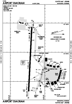
| Name: | Hunter AAF Airport |
| ICAO / IATA: | KSVN / SVN |
| FAA: | SVN |
Details |
| Type: | Airport (Airfield) |
| Use: | Military |
| Latitude: | 32°00'36"N (32.010020) |
| Longitude: | 81°08'46"W (-81.145987) |
| Datum: | WGS 1984 |
| Elevation: | 41 ft (12 m) |
| Runways: | 1 |
| Longest: | 11375 × 197 ft (3467 × 60 m) |
Time |
| Timezone: | UTC+29:08 (DST+32:08) |
| Local Time: | |
Weather |
| METAR: | KSVN | 041356Z 33004KT 10SM CLR 11/10 A3008 RMK AO2A SLP189 T01110103 FZRANO $
|
| TAF: | KSVN | 041300Z 0413/0519 27006KT 4800 FG SKC QNH3003INS BECMG 0414/0415 31006KT 9999 NSW SCT015 QNH3005INS BECMG 0500/0501 26006KT 9999 BKN100 QNH3002INS BECMG 0515/0516 29006KT 9999 BKN040 QNH3013INS TX19/0420Z TN07/0413Z
|
Related Locations |
| Nearby: | |
| Farthest: | MQZ: 11492 mi / 18495 km
Margaret River [Margaret River Airport], WA, AU |
Find: |
|
Other Information |
Maps:
|
Links:
|
Sources:
|
|