| Location |
| City: | | St. Maarten, Sint Maarten |
| Near (Alt.): | Philipsburg |
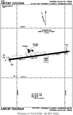
| Name: | Princess Juliana International Airport |
| ICAO / IATA: | TNCM / SXM |
Details |
| Type: | Airport (Aerodrome, Airfield) |
| Use: | Public/Civil |
| Latitude: | 18°02'27"N (18.040953) |
| Longitude: | 63°06'32"W (-63.108899) |
| Datum: | WGS 1984 |
| Elevation: | 14 ft (4 m) |
| Runways: | 1 |
| Longest: | 7708 × 148 ft (2349 × 45 m) |
Time |
| Timezone: | UTC+30:08 (DST+32:08) |
| Local Time: | |
Weather |
| METAR: | TNCM | 041400Z 10010KT 070V140 9999 SCT018 27/20 Q1017 A3003 NOSIG RMK SHRA SE
|
| TAF: | TNCM | 041141Z 0412/0512 09008KT P6SM FEW020
FM041400 11010KT P6SM VCSH SCT022
FM050000 08006KT P6SM FEW020
|
Related Locations |
| Nearby: | |
| Farthest: | WHM: 12248 mi / 19711 km
Wickham, WA, AU |
Find: |
|
Other Information |
Maps:
|
Links:
|
Sources:
|
|