| Location |
| City: | | Shemya, Alaska, United States |
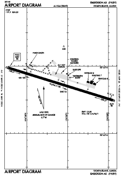
| Name: | Eareckson Air Station |
| ICAO / IATA: | PASY / SYA |
| FAA: | SYA |
Details |
| Type: | Airport (Airfield) |
| Use: | Military |
| Latitude: | 52°42'44"N (52.712258) |
| Longitude: | 174°06'49"E (174.113589) |
| Datum: | WGS 1984 |
| Elevation: | 97 ft (30 m) |
| Runways: | 1 |
| Longest: | 10005 × 150 ft (3050 × 45.5 m) |
Time |
| Timezone: | UTC+24:08 (DST+27:08) |
| Local Time: | |
Weather |
| METAR: | PASY | 041358Z 32009KT 7SM CLR M01/M04 A2935 RMK AO2 SLP942 RVRNO FZRANO $
|
| TAF: | PASY | 041400Z 0414/0520 30006KT 9999 FEW020 QNH2925INS BECMG 0508/0509 11012G18KT 9999 SCT015 BKN020 620206 QNH2910INS BECMG 0511/0512 10020G25KT 4800 -SHSN BKN010 BKN015 610157 QNH2893INS TX04/0506Z TNM07/0415Z
|
Related Locations |
| Nearby: | |
| Farthest: | FAGE: 11556 mi / 18597 km
Gough Island (Conçalo Álvares), TA, SH |
Find: |
|
Other Information |
Maps:
|
Links:
|
Sources:
|
|