| Location |
| City: | | Terceira, Região Autónoma dos Açores (Azores), Portugal |
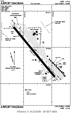
| Name: | Aeroporto das Lajes |
| ICAO / IATA: | LPLA / TER |
Details |
| Type: | Airport (Aerodrome, Airfield) |
| Use: | Public/Civil, Military |
| Latitude: | 38°45'43"N (38.761842) |
| Longitude: | 27°05'27"W (-27.090796) |
| Datum: | WGS 1984 |
| Elevation: | 180 ft (55 m) |
| Runways: | 1 |
| Longest: | 10870 × 197 ft (3313 × 60 m) |
Time |
| Timezone: | UTC+33:08 (DST+36:08) |
| Local Time: | |
Weather |
| METAR: | LPLA | 041400Z /////KT 9999 FEW009 SCT012 BKN018 18/16 Q1020
|
| TAF: | LPLA | 041102Z 0412/0512 20015KT 9999 SCT015 BKN025 TEMPO 0412/0512 5000 -RADZ BR SCT006 BKN012 TEMPO 0412/0422 22018G28KT PROB40 TEMPO 0421/0505 3000 RADZ BR SCT003 BKN006 BECMG 0423/0501 28008KT BECMG 0505/0507 36015KT
|
Related Locations |
| Nearby: | |
| Farthest: | XMC: 12249 mi / 19713 km
Mallacoota, Vic, AU |
Find: |
|
Other Information |
Maps:
|
Sources:
|
|