| Location |
| City: | | Tallahassee, Florida, United States |
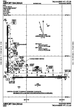
| Name: | Tallahassee International Airport |
| ICAO / IATA: | KTLH / TLH |
| FAA: | TLH |
Details |
| Type: | Airport (Part 139 Class I) |
| Use: | Public/Civil |
| Latitude: | 30°23'48"N (30.396754) |
| Longitude: | 84°21'03"W (-84.350868) |
| Datum: | WGS 1984 |
| Elevation: | 83 ft (25 m) |
| Runways: | 2 |
| Longest: | 8000 × 150 ft (2438 × 45.5 m) |
Time |
| Timezone: | UTC+29:08 (DST+32:08) |
| Local Time: | |
Weather |
| METAR: | KTLH | 041353Z 08005KT 10SM BKN026 BKN100 BKN250 14/13 A3009 RMK AO2 SLP188 T01390133
|
| TAF: | KTLH | 041229Z 0412/0512 12004KT P6SM BKN020
FM041900 19005KT P6SM BKN035
FM050400 00000KT 1SM BR SCT001 BKN010
FM050600 00000KT 1/2SM FG BKN003
|
Related Locations |
| Nearby: | |
| Farthest: | USL: 11326 mi / 18227 km
Useless Loop, WA, AU |
Find: |
|
Other Information |
Maps:
|
Delays:
|
Links:
|
Sources:
|
|