| Location |
| City: | | Toledo, Ohio, United States |
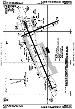
| Name: | Eugene F Kranz Toledo Express Airport |
| ICAO / IATA: | KTOL / TOL |
| FAA: | TOL |
Details |
| Type: | Airport (Part 139 Class I) |
| Use: | Public/Civil |
| Latitude: | 41°35'13"N (41.586817) |
| Longitude: | 83°48'28"W (-83.807826) |
| Datum: | WGS 1984 |
| Elevation: | 683 ft (208 m) |
| Runways: | 2 |
| Longest: | 10600 × 150 ft (3231 × 45.5 m) |
Time |
| Timezone: | UTC+29:08 (DST+32:08) |
| Local Time: | |
Weather |
| METAR: | KTOL | 041352Z 18006KT 10SM BKN070 BKN085 08/04 A2987 RMK AO2 SLP118 T00780044
|
| TAF: | KTOL | 041124Z 0412/0512 17005KT P6SM OVC050
FM041800 19010G20KT P6SM VCSH OVC030
FM042000 21010G20KT 1 1/2SM -SHRA BR OVC008
FM042300 21010G20KT 3SM -SHRA BR OVC003
FM050300 26010G20KT P6SM BKN080
FM050700 29010KT P6SM BKN100
|
Related Locations |
| Nearby: | |
| Farthest: | YAUG: 11293 mi / 18175 km
Augusta [Augusta Airport], WA, AU |
Find: |
|
Other Information |
Maps:
|
Delays:
|
Links:
|
Sources:
|
|