| Location |
| City: | | Portland, Oregon, United States |
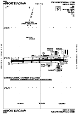
| Name: | Portland-Troutdale Airport |
| ICAO / IATA: | KTTD / TTD |
| FAA: | TTD |
Details |
| Type: | Airport (Airfield) |
| Use: | Public/Civil |
| Latitude: | 45°32'58"N (45.549361) |
| Longitude: | 122°24'04"W (-122.401249) |
| Datum: | WGS 1984 |
| Elevation: | 38 ft (12 m) |
| Runways: | 1 |
| Longest: | 5399 × 150 ft (1646 × 45.5 m) |
Time |
| Timezone: | UTC+26:08 (DST+29:08) |
| Local Time: | |
Weather |
| METAR: | KTTD | 041353Z AUTO 09004KT 10SM OVC040 02/00 A2946 RMK AO2 SLP974 T00220000
|
| TAF: | KTTD | 041139Z 0412/0512 10009KT 6SM -SHRASN FEW006 BKN012 OVC035 TEMPO 0414/0418 2SM -SHSN BKN006 OVC012
FM041800 10010KT 6SM -SHRASN BKN015 OVC030 TEMPO 0418/0422 2SM -SHSN BKN008 OVC020
FM042200 09013KT P6SM -SHSN SCT015 BKN035 BKN050
FM050100 09010KT P6SM VCSH SCT020 BKN040
|
Related Locations |
| Nearby: | |
| Farthest: | FAME: 11491 mi / 18493 km
Marion Island, Prince Edward Islands, WC, ZA |
Find: |
|
Other Information |
Maps:
|
Links:
|
Sources:
|
|