| Location |
| City: | | Traverse City, Michigan, United States |
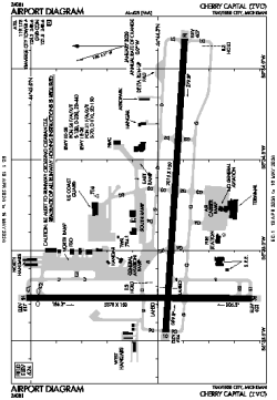
| Name: | Cherry Capital Airport |
| ICAO / IATA: | KTVC / TVC |
| FAA: | TVC |
Details |
| Type: | Airport (Part 139 Class I) |
| Use: | Public/Civil |
| Latitude: | 44°44'30"N (44.741579) |
| Longitude: | 85°34'55"W (-85.581869) |
| Datum: | WGS 1984 |
| Elevation: | 623 ft (190 m) |
| Runways: | 2 |
| Longest: | 7016 × 150 ft (2138 × 45.5 m) |
Time |
| Timezone: | UTC+29:08 (DST+32:08) |
| Local Time: | |
Weather |
| METAR: | KTVC | 041353Z VRB03KT 8SM FEW013 SCT085 OVC170 07/06 A2964 RMK AO2 RAB26E36 SLP042 P0000 T00720061
|
| TAF: | KTVC | 041412Z 0414/0512 VRB03KT P6SM VCSH SCT015 OVC050
FM041700 20009KT 3SM -SHRA BR BKN015 OVC030 WS020/22040KT
FM050000 28011G21KT 3SM -SHRA BR OVC008
FM050300 31013G22KT P6SM VCSH OVC015
|
Related Locations |
| Nearby: | |
| Farthest: | YAUG: 11124 mi / 17902 km
Augusta [Augusta Airport], WA, AU |
Find: |
|
Other Information |
Maps:
|
Delays:
|
Links:
|
Sources:
|
|