| Location |
| City: | | Knoxville, Tennessee, United States |
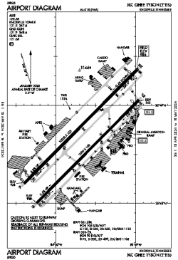
| Name: | McGhee Tyson Airport |
| ICAO / IATA: | KTYS / TYS |
| FAA: | TYS |
Details |
| Type: | Airport (Part 139 Class I) |
| Use: | Public/Civil |
| Latitude: | 35°48'40"N (35.811091) |
| Longitude: | 83°59'39"W (-83.994066) |
| Datum: | WGS 1984 |
| Elevation: | 986 ft (301 m) |
| Runways: | 2 |
| Longest: | 10000 × 150 ft (3048 × 45.5 m) |
Time |
| Timezone: | UTC+29:08 (DST+32:08) |
| Local Time: | |
Weather |
| METAR: | KTYS | 041413Z 00000KT 1/2SM BR FEW002 BKN250 04/04 A3008 RMK AO2 SFC VIS 2 T00390039
|
| TAF: | KTYS | 041122Z 0412/0512 VRB02KT 1/2SM FG BKN001
FM041330 00000KT 3SM BR BKN010
FM041430 VRB03KT P6SM SCT040 BKN250
FM041900 23007KT P6SM SCT035 OVC090
FM050000 23004KT P6SM VCSH SCT020 OVC035
FM050600 23003KT 3SM BR VCSH SCT010 OVC020
|
Related Locations |
| Nearby: | |
| Farthest: | YAUG: 11355 mi / 18274 km
Augusta [Augusta Airport], WA, AU |
Find: |
|
Other Information |
Maps:
|
Delays:
|
Links:
|
Sources:
|
|