| Location |
| City: | | Tuzla, Federation of Bosnia and Herzegovinas, Bosnia and Herzegovina |
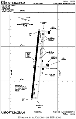
| Name: | Tuzla International Airport |
| ICAO / IATA: | LQTZ / TZL |
Details |
| Type: | Airport (Aerodrome, Airfield) |
| Use: | Public/Civil, Military |
| Latitude: | 44°27'31"N (44.458656) |
| Longitude: | 18°43'29"E (18.724783) |
| Datum: | WGS 1984 |
| Elevation: | 784 ft (239 m) |
| Runways: | 1 |
| Longest: | 8152 × 148 ft (2485 × 45 m) |
Time |
| Timezone: | UTC+1 (DST+4) |
| Local Time: | |
Weather |
| METAR: | LQTZ | 041400Z 28003KT 140V310 5000 -RA BR BKN007 OVC013 02/01 Q1028
|
| TAF: | LQTZ | 031700Z 0318/0418 31006KT 9999 BKN040 TX05/0413Z TN01/0406Z TEMPO 0401/0418 3000 -RA BR BKN013 OVC025 PROB40 TEMPO 0415/0418 2000 -RASN BKN010 OVC020
|
Related Locations |
| Nearby: | |
| Farthest: | CHT: 11685 mi / 18806 km
Waitangi [Tuuta], CIT, NZ |
Find: |
|
Other Information |
Maps:
|
Links:
|
Sources:
|
|