world map with UHMM marked

UHMM - Airport

This information may not be accurate or current and is not valid for navigation or flight planning. No warranty of fitness for any purpose is made or implied.

flag of Magadanskayaflag of Russian Federation (Russia)

Donate via PayPal

Additional information is available on the NEW Great Circle Mapper

Location
City:  Magadan, Magadanskaya, Russian Federation (Russia)
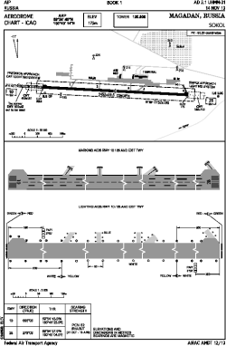
Name:Sokol
ICAO / IATA:UHMM / GDX

Details
Type:Airport (Aerodrome, Airfield)
Use:Public/Civil
Latitude:59°54'40"N (59.911111)
Longitude:150°43'14"E (150.720556)
Elevation:574 ft (175 m)
Runways:1
Longest:11325 × 195 ft (3452 × 59.5 m)

Time
Timezone:UTC+11 (DST+12)

Weather
METAR:UHMM  041400Z 09002MPS 9999 -SN NSC M20/M22 Q1001 RMK QFE736
TAF:UHMM  041353Z 0415/0521 02003G08MPS 9999 BKN030 OVC070 TEMPO 0415/0421 3100 -SHSN BKN020CB OVC070

Related Locations
Nearby:
Farthest:SAWB: 11505 mi / 18515 km
Base Marambio, Seymour Island, AQ

Find:

   beyond  
but within

Other Information
Maps:
Links:
Sources:


Airport Diagram

Airport diagram for UHMM

Airport diagram PDF


Great Circle Mapper   Great Circle Mapper
Great Circle Mapper FAQ   Great Circle Mapper FAQ
  Karl's Home Page
KLSē   KLSē Home
   GC on Facebook
Airlines of the World   Airlines of the World
Donate via PayPal


Copyright © 2004-2023, Karl L. Swartz. All rights reserved.
All trademarks mentioned herein belong to their respective owners.

Please see credits for attribution and copyright information.

Karl Swartz <karl@kls2.com>
  Powered by FreeBSD
Valid HTML 4.01!
Labeled with ICRA
hCard Microformat
Geo Microformat