| Location |
| City: | | Arkhangelsk, Arkhangelskaya, Russian Federation (Russia) |
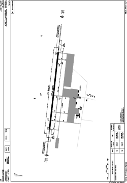
| Name: | Talagi Airport |
| ICAO / IATA: | ULAA / ARH |
Details |
| Type: | Airport (Aerodrome, Airfield) |
| Use: | Public/Civil |
| Latitude: | 64°36'01"N (64.600278) |
| Longitude: | 40°43'00"E (40.716667) |
| Elevation: | 62 ft (19 m) |
| Runways: | 1 |
| Longest: | 8202 × 144 ft (2500 × 44 m) |
Time |
| Timezone: | UTC+3 (DST+4) |
Weather |
| METAR: | ULAA | 041400Z 12008MPS 090V150 9999 DRSN SCT016 M18/M21 Q1028 R08/420243 NOSIG RMK QFE770/1027
|
| TAF: | ULAA | 041400Z 0415/0515 12006G13MPS 4100 -SN BLSN BKN011 TEMPO 0415/0421 15007G17MPS 2100 -SHSN BLSN BKN011CB TEMPO 0421/0503 15008G19MPS 1000 SHSN BLSN BKN005 BKN011CB TEMPO 0503/0515 15006G15MPS 2100 -SHSN BLSN BKN007 BKN011CB
|
Related Locations |
| Nearby: | |
| Farthest: | NEMO: 11195 mi / 18016 km
Pacific Ocean [Oceanic Pole of Inaccessibility (Point Nemo)] |
Find: |
|
Other Information |
Maps:
|
Sources:
|
|