| Location |
| City: | | Kaliningrad, Kaliningradskaya, Russian Federation (Russia) |
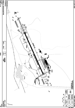
| Name: | Khrabrovo Airport |
| ICAO / IATA: | UMKK / KGD |
Details |
| Type: | Airport (Aerodrome, Airfield) |
| Use: | Public/Civil, Military |
| Latitude: | 54°53'24"N (54.890000) |
| Longitude: | 20°35'33"E (20.592500) |
| Elevation: | 43 ft (13 m) |
| Runways: | 1 |
| Longest: | 8202 × 148 ft (2500 × 45 m) |
Time |
| Timezone: | UTC+2 (DST+3) |
Weather |
| METAR: | UMKK | 041400Z 27003MPS 9999 OVC019 01/M02 Q1026 R24/19//60 NOSIG RMK QFE768/1024
|
| TAF: | UMKK | 041358Z 0415/0515 24003MPS 6000 OVC011 TEMPO 0415/0421 SCT005 BECMG 0419/0421 19005G10MPS TEMPO 0500/0506 BKN007 TEMPO 0506/0512 18007G14MPS TEMPO 0512/0515 3100 -SN BR BKN004
|
Related Locations |
| Nearby: | |
| Farthest: | CHT: 11354 mi / 18272 km
Waitangi [Tuuta], CIT, NZ |
Find: |
|
Other Information |
Maps:
|
Links:
|
Sources:
|
|