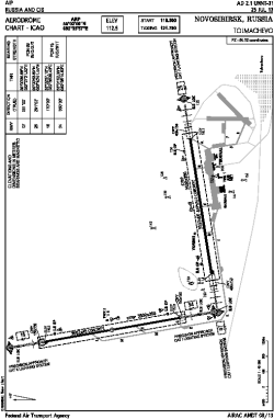
| Location |
| City: | | Novosibirsk, Novosibirskaya, Russian Federation (Russia) |
| Name: | Tolmachevo International Airport |
| ICAO / IATA: | UNNT / OVB |
Details |
| Type: | Airport (Aerodrome, Airfield) |
| Use: | Public/Civil |
| Latitude: | 55°02'00"N (55.033333) |
| Longitude: | 82°35'57"E (82.599167) |
| Elevation: | 368 ft (112 m) |
| Runways: | 2 |
| Longest: | 11818 × 148 ft (3602 × 45 m) |
Time |
| Timezone: | UTC+6 (DST+7) |
Weather |
| METAR: | UNNT | 041400Z 34001MPS CAVOK M35/M40 Q1039 R07/810160 R16/810160 NOSIG RMK QFE769/1025
|
| TAF: | UNNT | 041400Z 0415/0515 02003MPS CAVOK TEMPO 0415/0417 1500 FU BR BKN005 TEMPO 0417/0505 0600 FG FU BKN002
|
Related Locations |
| Nearby: | |
| Farthest: | PNT: 11388 mi / 18327 km
Puerto Natales [Teniente Julio Gallardo], MA, CL |
Find: |
|
Other Information |
Maps:
|
Links:
|
Sources:
|
|