| Location |
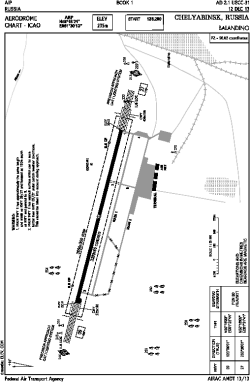
| City: | | Chelyabinsk, Chelyabinskaya, Russian Federation (Russia) |
| Name: | Balandino Airport |
| ICAO / IATA: | USCC / CEK |
Details |
| Type: | Airport (Aerodrome, Airfield) |
| Use: | Public/Civil |
| Latitude: | 55°18'21"N (55.305833) |
| Longitude: | 61°30'13"E (61.503611) |
| Elevation: | 771 ft (235 m) |
| Runways: | 1 |
| Longest: | 10499 × 197 ft (3200 × 60 m) |
Time |
| Timezone: | UTC+5 (DST+6) |
Weather |
| METAR: | USCC | 041400Z 35003MPS 5000 -SN BKN013 M23/M26 Q1032 R09/490540 TEMPO 0900 +SN VV003 RMK QFE753
|
| TAF: | USCC | 041400Z 0415/0515 35003G10MPS 3100 -SN BR OVC011 TEMPO 0415/0421 02003G08MPS
FM042100 36003G10MPS 3100 BR BKN011 TEMPO 0421/0515 10003G08MPS 1200 BR BKN003
|
Related Locations |
| Nearby: | |
| Farthest: | NEMO: 11940 mi / 19216 km
Pacific Ocean [Oceanic Pole of Inaccessibility (Point Nemo)] |
Find: |
|
Other Information |
Maps:
|
Sources:
|
|