| Location |
| City: | | St. Augustine, Florida, United States |
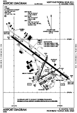
| Name: | Northeast Florida Regional |
| ICAO / IATA: | KSGJ / UST |
| FAA: | SGJ |
Details |
| Type: | Airport (Part 139 Class I) |
| Use: | Public/Civil |
| Latitude: | 29°57'33"N (29.959250) |
| Longitude: | 81°20'23"W (-81.339728) |
| Datum: | WGS 1984 |
| Elevation: | 9 ft (3 m) |
| Runways: | 3 |
| Longest: | 8001 × 150 ft (2439 × 45.5 m) |
Time |
| Timezone: | UTC+29:08 (DST+32:08) |
| Local Time: | |
Weather |
| METAR: | KSGJ | 041356Z 36005KT 5SM BR OVC006 13/12 A3012 RMK AO2 SLP197 T01330117
|
| TAF: | KSGJ | 041121Z 0412/0512 01006KT P6SM SCT003 OVC007
FM041800 06008KT P6SM SCT015 BKN025
FM042100 08008KT P6SM BKN250
FM050000 VRB03KT P6SM SCT250
FM051000 00000KT 5SM BR FEW250
|
Related Locations |
| Nearby: | |
| Farthest: | USL: 11508 mi / 18521 km
Useless Loop, WA, AU |
Find: |
|
Other Information |
Maps:
|
Links:
|
Sources:
|
|