| Location |
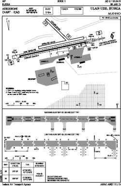
| City: | | Ulan-Ude, Buryatiya, Russian Federation (Russia) |
| Name: | Baikal International (Mukhino Airport) |
| ICAO / IATA: | UIUU / UUD |
Details |
| Type: | Airport (Aerodrome, Airfield) |
| Use: | Public/Civil |
| Latitude: | 51°48'28"N (51.807778) |
| Longitude: | 107°26'18"E (107.438333) |
| Elevation: | 1693 ft (516 m) |
| Runways: | 1 |
| Longest: | 9829 × 148 ft (2996 × 45 m) |
Time |
| Timezone: | UTC+8 (DST+9) |
Weather |
| METAR: | UIUU | 041400Z 34005MPS 9999 -SN FEW040 M25/M32 Q1024 R26/810555 NOSIG RMK QFE724/0965
|
| TAF: | UIUU | 041400Z 0415/0515 33003MPS 3100 -SN FU SCT030 TEMPO 0415/0418 1200 BR FU TEMPO 0418/0506 0700 FG VV001
|
Related Locations |
| Nearby: | |
| Farthest: | PNT: 12420 mi / 19989 km
Puerto Natales [Teniente Julio Gallardo], MA, CL |
Find: |
|
Other Information |
Maps:
|
Links:
|
Sources:
|
|