| Location |
| City: | | Samara, Samarskaya, Russian Federation (Russia) |
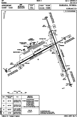
| Name: | Kurumoch International Airport |
| ICAO / IATA: | UWWW / KUF |
Details |
| Type: | Airport (Aerodrome, Airfield) |
| Use: | Public/Civil |
| Latitude: | 53°30'04"N (53.501111) |
| Longitude: | 50°09'14"E (50.153889) |
| Elevation: | 476 ft (145 m) |
| Runways: | 3 |
| Longest: | 9852 × 148 ft (3003 × 45 m) |
Time |
| Timezone: | UTC+4 (DST+5) |
Weather |
| METAR: | UWWW | 041400Z 06002MPS 4200 -SN BKN008 M05/M05 Q1027 R15/490538 NOSIG RMK QFE759/1012
|
| TAF: | UWWW | 041400Z 0415/0515 10003G09MPS 3100 -SN BR OVC011 TXM05/0415Z TNM12/0503Z TEMPO 0415/0503 VRB01MPS 0600 FZDZ FZFG VV003 BECMG 0503/0504 12006G13MPS TEMPO 0504/0515 15008G16MPS 0500 +SN BLSN VV002
|
Related Locations |
| Nearby: | |
| Farthest: | NEMO: 12008 mi / 19326 km
Pacific Ocean [Oceanic Pole of Inaccessibility (Point Nemo)] |
Find: |
|
Other Information |
Maps:
|
Links:
|
Sources:
|
|