| Location |
| City: | | Valdosta, Georgia, United States |
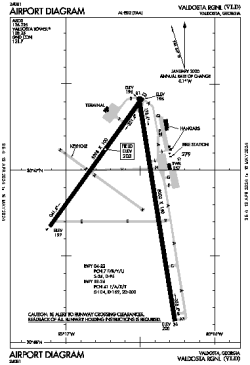
| Name: | Valdosta Regional |
| ICAO / IATA: | KVLD / VLD |
| FAA: | VLD |
Details |
| Type: | Airport (Part 139 Class I) |
| Use: | Public/Civil |
| Latitude: | 30°46'53"N (30.781465) |
| Longitude: | 83°16'33"W (-83.275971) |
| Datum: | WGS 1984 |
| Elevation: | 203 ft (62 m) |
| Runways: | 2 |
| Longest: | 8002 × 150 ft (2439 × 45.5 m) |
Time |
| Timezone: | UTC+29:08 (DST+32:08) |
| Local Time: | |
Weather |
| METAR: | KVLD | 041353Z 00000KT 10SM CLR 13/13 A3011 RMK AO2 SLP204 T01330133
|
| TAF: | KVLD | 041336Z 0414/0512 00000KT 5SM BR SCT015
FM041500 VRB03KT P6SM BKN025
FM041900 VRB03KT P6SM SCT025
FM050500 00000KT 1SM BR SCT001 BKN010
FM050900 00000KT 1/2SM FG BKN002
|
Related Locations |
| Nearby: | |
| Farthest: | USL: 11382 mi / 18318 km
Useless Loop, WA, AU |
Find: |
|
Other Information |
Maps:
|
Delays:
|
Links:
|
Sources:
|
|