| Location |
| City: | | Jacksonville, Florida, United States |
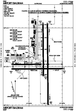
| Name: | Cecil Airport |
| ICAO / IATA: | KVQQ / VQQ |
| FAA: | VQQ |
Details |
| Type: | Airport (Airfield) |
| Use: | Public/Civil |
| Latitude: | 30°13'08"N (30.218778) |
| Longitude: | 81°52'38"W (-81.877166) |
| Datum: | WGS 1984 |
| Elevation: | 79 ft (24 m) |
| Runways: | 4 |
| Longest: | 12503 × 200 ft (3811 × 61 m) |
Time |
| Timezone: | UTC+29:08 (DST+32:08) |
| Local Time: | |
Weather |
| METAR: | KVQQ | 041350Z 35004KT 10SM OVC010 15/13 A3010
|
| TAF: | KVQQ | 041121Z 0412/0512 VRB03KT P6SM SCT007 OVC012
FM041700 06005KT P6SM SCT015 BKN025
FM041900 09005KT P6SM BKN250
FM050000 VRB02KT P6SM SCT250
FM050800 00000KT 3SM BR FEW250
|
Related Locations |
| Nearby: | |
| Farthest: | USL: 11473 mi / 18463 km
Useless Loop, WA, AU |
Find: |
|
Other Information |
Maps:
|
Links:
|
Sources:
|
|