| Location |
| City: | | Winnemucca, Nevada, United States |
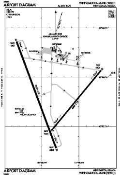
| Name: | Winnemucca Municipal Airport |
| ICAO / IATA: | KWMC / WMC |
| FAA: | WMC |
Details |
| Type: | Airport (Airfield) |
| Use: | Public/Civil |
| Latitude: | 40°53'48"N (40.896611) |
| Longitude: | 117°48'21"W (-117.805888) |
| Datum: | WGS 1984 |
| Elevation: | 4307 ft (1313 m) |
| Runways: | 2 |
| Longest: | 7000 × 100 ft (2134 × 30.5 m) |
Time |
| Timezone: | UTC+26:08 (DST+29:08) |
| Local Time: | |
Weather |
| METAR: | KWMC | 032021Z AUTO 16014G20KT 10SM -RA FEW010 BKN033 OVC055 03/02 A2955 RMK AO2 P0001 T00330022 $
|
| TAF: | KWMC | 041139Z 0412/0512 17009KT P6SM SCT040 OVC070
FM041500 16015G25KT 5SM -SHSNRA BR SCT025 OVC040
FM042100 21015G25KT P6SM VCSH SCT025 OVC040
FM050300 24010KT P6SM SCT025 OVC040 TEMPO 0503/0507 3SM -SHSN BR SCT015 OVC025
|
Related Locations |
| Nearby: | |
| Farthest: | FAME: 11162 mi / 17964 km
Marion Island, Prince Edward Islands, WC, ZA |
Find: |
|
Other Information |
Maps:
|
Links:
|
Sources:
|
|