| Location |
| City: | | Warner Robins, Georgia, United States |
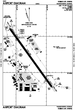
| Name: | Robins AFB |
| ICAO / IATA: | KWRB / WRB |
| FAA: | WRB |
Details |
| Type: | Airport (Airfield) |
| Use: | Military |
| Latitude: | 32°38'25"N (32.640171) |
| Longitude: | 83°35'31"W (-83.591920) |
| Datum: | WGS 1984 |
| Elevation: | 294 ft (90 m) |
| Runways: | 1 |
| Longest: | 12001 × 300 ft (3658 × 91.5 m) |
Time |
| Timezone: | UTC+29:08 (DST+32:08) |
| Local Time: | |
Weather |
| METAR: | KWRB | 041356Z 00000KT 1/8SM R33/1000V1400FT FG VV000 07/07 A3011 RMK AO2A SLP199 T00710071
|
| TAF: | KWRB | 040500Z 0405/0511 VRB06KT 9999 SCT020 QNH3005INS BECMG 0408/0409 VRB06KT 4800 BR SCT010 QNH3006INS BECMG 0415/0416 23006KT 9999 NSW FEW030 SCT080 QNH3007INS BECMG 0503/0504 20006KT 9999 BKN009 QNH3007INS TX21/0420Z TN06/0412Z
|
Related Locations |
| Nearby: | |
| Farthest: | MQZ: 11360 mi / 18282 km
Margaret River [Margaret River Airport], WA, AU |
Find: |
|
Other Information |
Maps:
|
Links:
|
Sources:
|
|