| Location |
| City: | | Wroclaw, Dolnoslaskie, Poland |
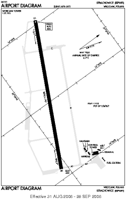
| Name: | Nicolaus Copernicus Airport Wroclaw (Strachowice) |
| ICAO / IATA: | EPWR / WRO |
Details |
| Type: | Airport (Aerodrome, Airfield) |
| Use: | Public/Civil |
| Latitude: | 51°06'10"N (51.102683) |
| Longitude: | 16°53'09"E (16.885836) |
| Datum: | WGS 1984 |
| Elevation: | 404 ft (123 m) |
| Runways: | 1 |
| Longest: | 8202 × 197 ft (2500 × 60 m) |
Time |
| Timezone: | UTC+1 (DST+4) |
| Local Time: | |
Weather |
| METAR: | EPWR | 041400Z 29009KT 9999 BKN026 01/M02 Q1030 R11/61//94
|
| TAF: | EPWR | 041130Z 0412/0512 28010KT 9999 BKN030 BECMG 0415/0418 17005KT TEMPO 0415/0420 4000 BR BKN005
|
Related Locations |
| Nearby: | |
| Farthest: | CHT: 11635 mi / 18724 km
Waitangi [Tuuta], CIT, NZ |
Find: |
|
Other Information |
Maps:
|
Links:
|
Sources:
|
|