| Location |
| City: | | Doha, Qatar |
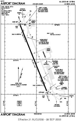
| Name: | Al Udeid AB (Abu Nakhlah Airport) |
| ICAO / IATA: | OTBH / XJD |
Details |
| Type: | Airport (Aerodrome, Airfield) |
| Use: | Military |
| Latitude: | 25°07'02"N (25.117317) |
| Longitude: | 51°18'54"E (51.314989) |
| Datum: | WGS 1984 |
| Elevation: | 130 ft (40 m) |
| Runways: | 1 |
| Longest: | 12303 × 148 ft (3750 × 45 m) |
Time |
| Timezone: | UTC+3 (DST+5) |
| Local Time: | |
Weather |
| METAR: | OTBH | 041356Z 34015KT 9999 CLR 19/07 A3017 RMK SLP219 T01910072 $
|
| TAF: | OTBH | 040700Z 0407/0513 34012G18KT 9000 HZ SKC QNH3016INS TEMPO 0408/0414 34015G25KT BECMG 0414/0415 33012G18KT 9000 HZ SKC QNH3016INS BECMG 0415/0416 32009KT 9000 HZ SKC QNH3018INS BECMG 0504/0505 32012G18KT 9000 HZ SKC QNH3018INS TX23/0409Z TN14/0502Z
|
Related Locations |
| Nearby: | |
| Farthest: | GMR: 12029 mi / 19359 km
Mangareva [Totegegie], Gambier Islands, PF |
Find: |
|
Other Information |
Maps:
|
Links:
|
Sources:
|
|