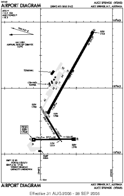
| Location |
| City: | | Alice Springs, Northern Territory, Australia |
| ICAO / IATA: | YBAS / ASP |
Details |
| Type: | Airport (Aerodrome, Airfield) |
| Use: | Public/Civil |
| Latitude: | 23°48'24"S (-23.806666) |
| Longitude: | 133°54'08"E (133.902222) |
| Datum: | WGS 1984 |
| Elevation: | 1789 ft (545 m) |
| Runways: | 2 |
| Longest: | 7999 × 148 ft (2438 × 45 m) |
Time |
| Timezone: | UTC+9:30 (DST+11:30) |
| Local Time: | |
Weather |
| METAR: | YBAS | 041400Z AUTO 16006KT 9999 // SCT110 30/10 Q1008 RF00.0/000.0
|
| TAF: | YBAS | 041115Z 0412/0512 13010KT CAVOK
FM041600 30005KT CAVOK
FM050100 15014KT CAVOK
|
Related Locations |
| Nearby: | |
| Farthest: | TAPT: 11345 mi / 18257 km
Barbuda [Coco Point Lodge], AG |
Find: |
|
Other Information |
Maps:
|
Sources:
|
|