| Location |
| City: | | Bagotville, Québec, Canada |
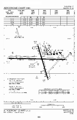
| Name: | CFB Bagotville (Bagotville Airport) |
| ICAO / IATA: | CYBG / YBG |
Details |
| Type: | Airport (Airfield) |
| Use: | Private, Military |
| Latitude: | 48°19'50"N (48.330556) |
| Longitude: | 70°59'47"W (-70.996388) |
| Elevation: | 522 ft (159 m) |
| Runways: | 2 |
| Longest: | 10000 ft (3048 m) |
Time |
| Timezone: | UTC+29:08 (DST+32:08) |
| Local Time: | |
Weather |
| METAR: | CYBG | 041400Z 30009G16KT 6SM -SN OVC023 M09/M12 A2997 RMK SC8 CIG VRB 17-29 SLP164
|
| TAF: | CYBG | 041130Z 0412/0512 VRB03KT P6SM SCT012 OVC025 TEMPO 0412/0415 3SM -FZDZ -SN BR OVC012
FM041500 VRB03KT P6SM SCT020 OVC030 TEMPO 0415/0418 OVC020
FM041800 30008KT P6SM SCT030 OVC080
FM050000 VRB03KT P6SM SCT030 OVC080 TEMPO 0500/0503 P6SM -SN OVC030
FM050300 09008KT P6SM -SN OVC030 TEMPO 0503/0506 3SM -SN -PL OVC020 PROB40 0503/0506 3SM -FZRA BR
FM050600 09015KT 6SM -FZRA BR OVC025 TEMPO 0506/0512 2SM -FZRA BR OVC012 RMK NXT FCST BY 041500Z
|
Related Locations |
| Nearby: | |
| Farthest: | YAUG: 11414 mi / 18369 km
Augusta [Augusta Airport], WA, AU |
Find: |
|
Other Information |
Maps:
|
Links:
|
Sources:
|
|