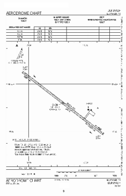
world map with YDB marked

YDB - Airport

This information may not be accurate or current and is not valid for navigation or flight planning. No warranty of fitness for any purpose is made or implied.

flag of Yukonflag of Canada

Donate via PayPal

Additional information is available on the NEW Great Circle Mapper

Location
City:  Burwash Landings, Yukon, Canada
ICAO / IATA:CYDB / YDB

Details
Type:Airport (Airfield)
Latitude:61°22'16"N (61.371111)
Longitude:139°02'26"W (-139.040555)
Datum:WGS 1984
Elevation:2647 ft (807 m)
Runways:1
Longest:5000 × 100 ft (1524 × 30.5 m)

Weather
METAR:CYDB  041416Z AUTO 11002KT 2 1/4SM -SN OVC026 M15/M18 A2990 RMK SLP202
TAF:CYDB  041138Z 0412/0424 VRB03KT P6SM OVC080 TEMPO 0412/0413 5SM -SN
FM041500 VRB03KT 6SM -SN OVC060 TEMPO 0415/0424 3SM -SN SCT020 OVC040 RMK FCST BASED ON AUTO OBS. NXT FCST BY 041800Z

Related Locations
Nearby:
Farthest:FAME: 11420 mi / 18378 km
Marion Island, Prince Edward Islands, WC, ZA

Find:

   beyond  
but within

Other Information
Maps:
Sources:


Airport Diagram

Airport diagram for YDB

Airport diagram PDF from NAV Canada


Great Circle Mapper   Great Circle Mapper
Great Circle Mapper FAQ   Great Circle Mapper FAQ
  Karl's Home Page
KLSē   KLSē Home
   GC on Facebook
Airlines of the World   Airlines of the World
Donate via PayPal


Copyright © 2004-2023, Karl L. Swartz. All rights reserved.
All trademarks mentioned herein belong to their respective owners.

Please see credits for attribution and copyright information.

Karl Swartz <karl@kls2.com>
  Powered by FreeBSD
Valid HTML 4.01!
Labeled with ICRA
hCard Microformat
Geo Microformat