| Location |
| City: | | Dawson Creek, British Columbia, Canada |
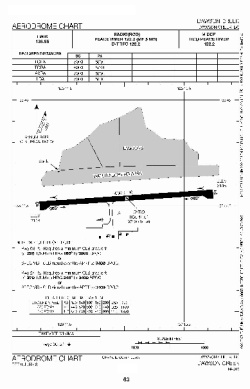
| Name: | Dawson Creek Airport |
| ICAO / IATA: | CYDQ / YDQ |
Details |
| Type: | Airport (Airfield) |
| Use: | Public/Civil |
| Latitude: | 55°44'32"N (55.742222) |
| Longitude: | 120°10'59"W (-120.183055) |
| Elevation: | 2147 ft (654 m) |
| Runways: | 1 |
| Longest: | 5001 ft (1524 m) |
Time |
| Timezone: | UTC+26:08 (DST+29:08) |
| Local Time: | |
Weather |
| METAR: | CYDQ | 041400Z AUTO 14004KT 120V230 1/2SM HZ VV002 M40/M45 A3019 RMK SLP329
|
| TAF: | CYDQ | 041238Z 0413/0501 VRB03KT 1/2SM IC FG VV002 TEMPO 0413/0418 11/2SM IC BR SCT002
FM041800 VRB03KT 1SM IC BR BKN003 BECMG 0418/0420 P6SM NSW SKC RMK FCST BASED ON AUTO OBS. NXT FCST BY 041900Z
|
Related Locations |
| Nearby: | |
| Farthest: | FAME: 11311 mi / 18204 km
Marion Island, Prince Edward Islands, WC, ZA |
Find: |
|
Other Information |
Maps:
|
Links:
|
Sources:
|
|