| Location |
| City: | | Radisson, Québec, Canada |
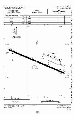
| Name: | La Grande Rivière Airport |
| ICAO / IATA: | CYGL / YGL |
Details |
| Type: | Airport (Airfield) |
| Use: | Public/Civil |
| Latitude: | 53°37'31"N (53.625278) |
| Longitude: | 77°42'15"W (-77.704166) |
| Elevation: | 640 ft (195 m) |
| Runways: | 1 |
| Longest: | 6487 ft (1977 m) |
Time |
| Timezone: | UTC+29:08 (DST+32:08) |
| Local Time: | |
Weather |
| METAR: | CYGL | 041412Z 24006KT 15SM BKN004 OVC240 M28/M32 A3006 RMK SF6CI2 SLP209
|
| TAF: | CYGL | 041139Z 0412/0512 31005KT P6SM SKC TEMPO 0412/0416 5SM IC
FM041600 28008KT P6SM SCT030 TEMPO 0416/0512 5SM -SN BKN020 BECMG 0500/0502 02006KT RMK NXT FCST BY 041800Z
|
Related Locations |
| Nearby: | |
| Farthest: | YCSK: 11508 mi / 18520 km
Casey Station [Casey Station Skiway], Wilkes Land, AQ |
Find: |
|
Other Information |
Maps:
|
Sources:
|
|