| Location |
| City: | | Geraldton, Ontario, Canada |
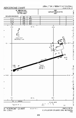
| Name: | Geraldton (Greenstone Regional) Airport |
| ICAO / IATA: | CYGQ / YGQ |
Details |
| Type: | Airport (Airfield) |
| Use: | Public/Civil |
| Latitude: | 49°46'43"N (49.778611) |
| Longitude: | 86°56'19"W (-86.938610) |
| Elevation: | 1143 ft (348 m) |
| Runways: | 1 |
| Longest: | 5007 ft (1526 m) |
Time |
| Timezone: | UTC+29:08 (DST+32:08) |
| Local Time: | |
Weather |
| METAR: | CYGQ | 041400Z 05011G17KT 1 1/4SM -SN DRSN OVC052 M23/M27 A3000 RMK SN4SC4 SLP202
|
| TAF: | CYGQ | 041338Z 0414/0502 05010G20KT 3/4SM -SN BLSN VV012 TEMPO 0414/0423 2SM -SN OVC015
FM042300 03010KT 11/2SM -SN OVC015 TEMPO 0423/0502 5SM -SN OVC025 RMK NXT FCST BY 042000Z
|
Related Locations |
| Nearby: | |
| Farthest: | YCSK: 11127 mi / 17908 km
Casey Station [Casey Station Skiway], Wilkes Land, AQ |
Find: |
|
Other Information |
Maps:
|
Sources:
|
|