| Location |
| City: | | Dryden, Ontario, Canada |
| Name: | Dryden Regional Airport |
| ICAO / IATA: | CYHD / YHD |
Details |
| Type: | Airport (Airfield) |
| Use: | Public/Civil |
| Latitude: | 49°49'53"N (49.831389) |
| Longitude: | 92°44'37"W (-92.743610) |
| Elevation: | 1354 ft (413 m) |
| Runways: | 2 |
| Longest: | 5996 ft (1828 m) |
Time |
| Timezone: | UTC+29:08 (DST+32:08) |
| Local Time: | |
Weather |
| METAR: | CYHD | 041400Z AUTO 04013G18KT 1SM R12/P6000FT/N -SN VV016 M21/M24 A2995 RMK SLP190
|
| TAF: | CYHD | 041338Z 0414/0502 05010G20KT 3/4SM -SN VV012 TEMPO 0414/0418 3SM -SN OVC025
FM041800 03010G20KT 11/2SM -SN VV012 TEMPO 0418/0424 5SM -SN OVC025
FM050000 01008KT P6SM BKN025 OVC080 TEMPO 0500/0502 BKN020 OVC080 RMK FCST BASED ON AUTO OBS. NXT FCST BY 042000Z
|
Related Locations |
| Nearby: | |
| Farthest: | YCSK: 11022 mi / 17738 km
Casey Station [Casey Station Skiway], Wilkes Land, AQ |
Find: |
|
Other Information |
Maps:
|
Sources:
|
|
|
|
Airport Diagram
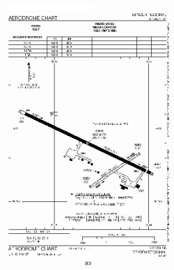
Airport diagram PDF from NAV Canada
|
