| Location |
| City: | | Detroit, Michigan, United States |
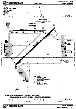
| Name: | Willow Run Airport |
| ICAO / IATA: | KYIP / YIP |
| FAA: | YIP |
Details |
| Type: | Airport (Part 139 Class IV) |
| Use: | Public/Civil |
| Latitude: | 42°14'25"N (42.240274) |
| Longitude: | 83°31'53"W (-83.531460) |
| Datum: | WGS 1984 |
| Elevation: | 715 ft (218 m) |
| Runways: | 2 |
| Longest: | 7543 × 150 ft (2299 × 45.5 m) |
Time |
| Timezone: | UTC+29:08 (DST+32:08) |
| Local Time: | |
Weather |
| METAR: | KYIP | 041353Z 19005KT 10SM BKN050 OVC060 07/04 A2986 RMK AO2 SLP113 T00720044
|
| TAF: | KYIP | 041120Z 0412/0512 18009KT P6SM SCT040 BKN070 TEMPO 0412/0414 5SM BR BKN040
FM041900 18014G22KT 6SM -SHRA BR BKN015 OVC040
FM050000 21012G18KT P6SM OVC015
FM050500 25010KT P6SM OVC025
FM051000 29008KT P6SM SCT025 BKN100
|
Related Locations |
| Nearby: | |
| Farthest: | YAUG: 11290 mi / 18170 km
Augusta [Augusta Airport], WA, AU |
Find: |
|
Other Information |
Maps:
|
Links:
|
Sources:
|
|