| Location |
| City: | | Stephenville, Newfoundland and Labrador, Canada |
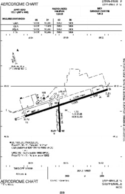
| Name: | Stephenville Dymond International Airport |
| ICAO / IATA: | CYJT / YJT |
Details |
| Type: | Airport (Airfield) |
| Use: | Public/Civil |
| Latitude: | 48°32'29"N (48.541389) |
| Longitude: | 58°33'00"W (-58.549999) |
| Elevation: | 81 ft (25 m) |
| Runways: | 2 |
| Longest: | 10011 ft (3051 m) |
Time |
| Timezone: | UTC+30:38 (DST+33:38) |
| Local Time: | |
Weather |
| METAR: | CYJT | 041400Z 20015KT 15SM SCT022 BKN100 M07/M10 A3008 RMK SC3AC4 SLP189
|
| TAF: | CYJT | 041141Z 0412/0512 20012KT 5SM -SN BKN020 OVC120 TEMPO 0412/0415 P6SM NSW SCT020 OVC120 BECMG 0412/0414 21015G25KT
FM041500 22015G25KT 11/2SM -SN VV015 TEMPO 0415/0424 3SM -SN OVC030 PROB30 0415/0424 3/4SM -SN BLSN VV006
FM050000 28014KT P6SM -SHSN OVC030 BECMG 0501/0503 30012KT BECMG 0507/0509 VRB03KT RMK NXT FCST BY 041800Z
|
Related Locations |
| Nearby: | |
| Farthest: | ALH: 11473 mi / 18465 km
Albany, WA, AU |
Find: |
|
Other Information |
Maps:
|
Links:
|
Sources:
|
|