| Location |
| City: | | Lloydminster, Alberta, Canada |
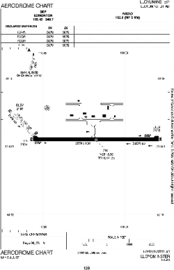
| Name: | Lloydminster Airport |
| ICAO / IATA: | CYLL / YLL |
Details |
| Type: | Airport (Airfield) |
| Use: | Public/Civil |
| Latitude: | 53°18'38"N (53.310556) |
| Longitude: | 110°04'27"W (-110.074166) |
| Elevation: | 2194 ft (669 m) |
| Runways: | 2 |
| Longest: | 5579 ft (1700 m) |
Time |
| Timezone: | UTC+27:08 (DST+30:08) |
| Local Time: | |
Weather |
| METAR: | CYLL | 041400Z 06004KT 4SM -SN BKN032 OVC095 M27/M31 A3020 RMK SC6AC2 /S01 AFT 00 UTC/ SLP314
|
| TAF: | CYLL | 041138Z 0412/0424 09008KT P6SM -SN SCT040 OVC080 TEMPO 0412/0424 21/2SM -SN OVC040 PROB30 0421/0424 1SM -SHSN RMK FCST BASED ON AUTO OBS. NXT FCST BY 041800Z
|
Related Locations |
| Nearby: | |
| Farthest: | FAME: 10958 mi / 17635 km
Marion Island, Prince Edward Islands, WC, ZA |
Find: |
|
Other Information |
Maps:
|
Sources:
|
|