| Location |
| City: | | Chibougamau, Québec, Canada |
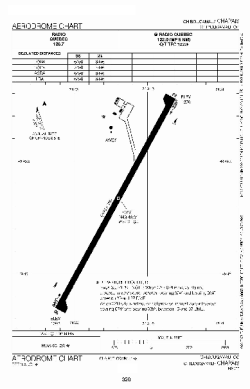
| Name: | Chapais Airport |
| ICAO / IATA: | CYMT / YMT |
Details |
| Type: | Airport (Airfield) |
| Use: | Public/Civil |
| Latitude: | 49°46'19"N (49.771944) |
| Longitude: | 74°31'41"W (-74.528055) |
| Elevation: | 1270 ft (387 m) |
| Runways: | 1 |
| Longest: | 6495 ft (1980 m) |
Time |
| Timezone: | UTC+29:08 (DST+32:08) |
| Local Time: | |
Weather |
| METAR: | CYMT | 041401Z AUTO 33007KT 9SM SCT014 M17/M21 A2996 RMK SLP186
|
| TAF: | CYMT | 041243Z 0413/0501 31008KT P6SM SCT015 BKN120 TEMPO 0413/0423 5SM -SN BKN015 BKN120 BECMG 0419/0421 05005KT
FM042300 09012KT 2SM -SN VV010 TEMPO 0423/0501 3/4SM -SN VV006 RMK FCST BASED ON AUTO OBS. NXT FCST BY 041800Z
|
Related Locations |
| Nearby: | |
| Farthest: | YCSK: 11272 mi / 18140 km
Casey Station [Casey Station Skiway], Wilkes Land, AQ |
Find: |
|
Other Information |
Maps:
|
Sources:
|
|