| Location |
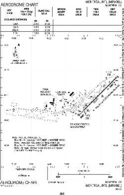
| City: | | Montréal, Québec, Canada |
| Name: | Montréal-Mirabel International Airport |
| ICAO / IATA: | CYMX / YMX |
Details |
| Type: | Airport (Airfield) |
| Use: | Public/Civil |
| Latitude: | 45°40'47"N (45.679722) |
| Longitude: | 74°02'19"W (-74.038610) |
| Elevation: | 271 ft (83 m) |
| Runways: | 2 |
| Longest: | 12000 ft (3658 m) |
Time |
| Timezone: | UTC+29:08 (DST+32:08) |
| Local Time: | |
Weather |
| METAR: | CYMX | 041400Z 25003KT 200V270 6SM -FZDZ BR BKN004 OVC025 M07/M08 A2999 RMK SF6SC2 SLP163
|
| TAF: | CYMX | 041148Z 0412/0512 VRB03KT 2SM -FZDZ BR OVC004 TEMPO 0412/0418 6SM BR OVC010 BECMG 0413/0415 07005KT
FM041800 05006KT 4SM -FZDZ BR OVC005
FM050500 08007KT 2SM -FZRA BR OVC003
FM050800 23010KT 1SM -DZ BR OVC003
FM051100 25015KT 3SM -DZ BR OVC007 RMK NXT FCST BY 041800Z
|
Related Locations |
| Nearby: | |
| Farthest: | YAUG: 11512 mi / 18527 km
Augusta [Augusta Airport], WA, AU |
Find: |
|
Other Information |
Maps:
|
Links:
|
Sources:
|
|