| Location |
| City: | | Oshawa, Ontario, Canada |
| Near (Alt.): | Toronto |
| Name: | Oshawa Municipal Airport |
| ICAO / IATA: | CYOO / YOO |
Details |
| Type: | Airport (Airfield) |
| Use: | Public/Civil |
| Latitude: | 43°55'22"N (43.922778) |
| Longitude: | 78°53'48"W (-78.896666) |
| Elevation: | 460 ft (140 m) |
| Runways: | 2 |
| Longest: | 3999 ft (1219 m) |
Time |
| Timezone: | UTC+29:08 (DST+32:08) |
| Local Time: | |
Weather |
| METAR: | CYOO | 041400Z AUTO 00000KT 1/4SM FG FEW016 BKN034 OVC080 03/03 A2992 RMK SLP139
|
| TAF: | CYOO | 041338Z 0414/0502 VRB03KT 1/8SM FG BKN006 OVC070 TEMPO 0414/0416 6SM -DZ BR SCT006 OVC070
FM041600 20007KT P6SM SCT020 BKN230 TEMPO 0416/0424 BKN020 OVC230
FM050000 18007KT P6SM -RA SCT020 OVC030 RMK FCST BASED ON AUTO OBS. NXT FCST BY 042000Z
|
Related Locations |
| Nearby: | |
| Farthest: | YAUG: 11435 mi / 18403 km
Augusta [Augusta Airport], WA, AU |
Find: |
|
Other Information |
Maps:
|
Sources:
|
|
|
|
Airport Diagram
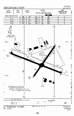
Airport diagram PDF from NAV Canada
|
