| Location |
| City: | | Pickle Lake, Ontario, Canada |
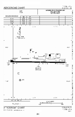
| Name: | Pickle Lake Airport |
| ICAO / IATA: | CYPL / YPL |
Details |
| Type: | Airport (Airfield) |
| Use: | Public/Civil |
| Latitude: | 51°26'47"N (51.446389) |
| Longitude: | 90°12'51"W (-90.214166) |
| Elevation: | 1267 ft (386 m) |
| Runways: | 1 |
| Longest: | 4921 ft (1500 m) |
Time |
| Timezone: | UTC+29:08 (DST+32:08) |
| Local Time: | |
Weather |
| METAR: | CYPL | 041400Z 02005KT 15SM -SN OVC070 M27/M31 A3009 RMK AC8 SLP241
|
| TAF: | CYPL | 041243Z 0413/0501 03008KT P6SM FEW020 BKN060 TEMPO 0413/0414 5SM -SN BKN020
FM041400 03008KT 11/2SM -SN OVC015 TEMPO 0414/0424 6SM -SN OVC025 BECMG 0418/0420 02012KT
FM050000 01012KT 5SM -SN BKN025 RMK NXT FCST BY 042000Z
|
Related Locations |
| Nearby: | |
| Farthest: | YCSK: 11172 mi / 17979 km
Casey Station [Casey Station Skiway], Wilkes Land, AQ |
Find: |
|
Other Information |
Maps:
|
Sources:
|
|