| Location |
| City: | | Windsor, Ontario, Canada |
| Name: | Windsor Airport |
| ICAO / IATA: | CYQG / YQG |
Details |
| Type: | Airport (Airfield) |
| Use: | Public/Civil |
| Latitude: | 42°16'34"N (42.276111) |
| Longitude: | 82°57'19"W (-82.955277) |
| Elevation: | 622 ft (190 m) |
| Runways: | 2 |
| Longest: | 9000 ft (2743 m) |
Time |
| Timezone: | UTC+29:08 (DST+32:08) |
| Local Time: | |
Weather |
| METAR: | CYQG | 041400Z AUTO 19010KT 9SM BKN055 OVC076 06/04 A2988 RMK SLP122
|
| TAF: | CYQG | 041139Z 0412/0512 19010KT P6SM SCT020 OVC050 TEMPO 0412/0418 BKN020 OVC050
FM041800 19015KT P6SM BKN050
FM042000 19015G25KT 2SM -RA BR OVC005
FM050000 23015G25KT 3/4SM -RA BR OVC003
FM050200 27010KT 2SM -DZ BR OVC005
FM050500 30015KT 6SM BR OVC007 BECMG 0508/0510 30010KT RMK FCST BASED ON AUTO OBS. NXT FCST BY 041800Z
|
Related Locations |
| Nearby: | |
| Farthest: | YAUG: 11316 mi / 18212 km
Augusta [Augusta Airport], WA, AU |
Find: |
|
Other Information |
Maps:
|
Sources:
|
|
|
|
Airport Diagram
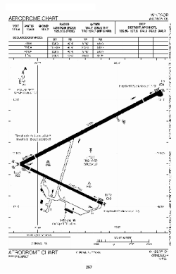
Airport diagram PDF from NAV Canada
|
