| Location |
| City: | | Kenora, Ontario, Canada |
| Name: | Kenora Airport |
| ICAO / IATA: | CYQK / YQK |
Details |
| Type: | Airport (Airfield) |
| Use: | Public/Civil |
| Latitude: | 49°47'18"N (49.788333) |
| Longitude: | 94°21'47"W (-94.363055) |
| Elevation: | 1344 ft (410 m) |
| Runways: | 1 |
| Longest: | 5800 ft (1768 m) |
Time |
| Timezone: | UTC+29:08 (DST+32:08) |
| Local Time: | |
Weather |
| METAR: | CYQK | 041400Z 04010G16KT 1/2SM -SN BLSN VV005 M21/M23 A2997 RMK SN8 SLP192
|
| TAF: | CYQK | 041338Z 0414/0502 03010G20KT 3/4SM -SN VV006 TEMPO 0414/0418 3SM -SN OVC012
FM041800 02010G20KT 2SM -SN OVC010 TEMPO 0418/0421 5SM -SN OVC025
FM042100 01010KT P6SM BKN025 OVC080 RMK NXT FCST BY 042000Z
|
Related Locations |
| Nearby: | |
| Farthest: | YCSK: 10985 mi / 17679 km
Casey Station [Casey Station Skiway], Wilkes Land, AQ |
Find: |
|
Other Information |
Maps:
|
Sources:
|
|
|
|
Airport Diagram
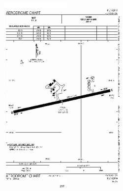
Airport diagram PDF from NAV Canada
|
