| Location |
| City: | | Moncton, New Brunswick, Canada |
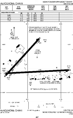
| Name: | Greater Moncton International Airport |
| ICAO / IATA: | CYQM / YQM |
Details |
| Type: | Airport (Airfield) |
| Use: | Public/Civil |
| Latitude: | 46°06'58"N (46.116111) |
| Longitude: | 64°40'43"W (-64.678610) |
| Elevation: | 232 ft (71 m) |
| Runways: | 2 |
| Longest: | 10001 ft (3048 m) |
Time |
| Timezone: | UTC+30:08 (DST+33:08) |
| Local Time: | |
Weather |
| METAR: | CYQM | 041400Z 17010KT 15SM FEW008 OVC013 M03/M04 A2994 RMK SF1SC8 SF TR SLP144
|
| TAF: | CYQM | 041139Z 0412/0512 16012KT P6SM OVC025 TEMPO 0412/0416 21/2SM -SN SCT008 OVC015
FM041600 20012KT P6SM OVC015 TEMPO 0416/0418 5SM -RASN -DZ BR
FM041800 24012KT 6SM -RA -DZ BR OVC015
FM042000 26008KT P6SM BKN015 OVC025 BECMG 0422/0424 32008KT
FM050400 06008KT 6SM BR BKN008 OVC015 PROB40 0504/0509 2SM -FZDZ BR
FM050900 11008KT 2SM BR OVC004 PROB40 0509/0512 11/2SM -FZDZ BR OVC003 RMK NXT FCST BY 041800Z
|
Related Locations |
| Nearby: | |
| Farthest: | YDEK: 11652 mi / 18752 km
Denmark, WA, AU |
Find: |
|
Other Information |
Maps:
|
Sources:
|
|