| Location |
| City: | | Thunder Bay, Ontario, Canada |
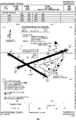
| Name: | Thunder Bay International Airport |
| ICAO / IATA: | CYQT / YQT |
Details |
| Type: | Airport (Airfield) |
| Use: | Public/Civil |
| Latitude: | 48°22'19"N (48.371944) |
| Longitude: | 89°19'18"W (-89.321666) |
| Elevation: | 654 ft (199 m) |
| Runways: | 2 |
| Longest: | 7318 ft (2231 m) |
Time |
| Timezone: | UTC+29:08 (DST+32:08) |
| Local Time: | |
Weather |
| METAR: | CYQT | 041400Z 01006KT 350V050 2SM -SN OVC028 M16/M19 A2991 RMK SC8 VIS VRB 1 1/2 - 2 1/2 /S01/ SLP149
|
| TAF: | CYQT | 041338Z 0414/0502 02010G20KT 1/2SM SN VV006 TEMPO 0414/0418 3SM -SN OVC020
FM041900 35010G20KT 1SM -SN VV012 TEMPO 0419/0502 3SM -SN OVC025 RMK NXT FCST BY 042000Z
|
Related Locations |
| Nearby: | |
| Farthest: | YCSK: 10996 mi / 17697 km
Casey Station [Casey Station Skiway], Wilkes Land, AQ |
Find: |
|
Other Information |
Maps:
|
Sources:
|
|